3 plates, 6 faults behind quakes: 24 districts including Dhaka at high risk
At least 10 people have been killed in Narsingdi, Dhaka and Narayanganj in the powerful earthquake that jolted various parts of the country including the capital on Friday (21 November). Several hundred people have been injured. The tremor, felt at 10:38am, is being described as the most devastating in decades. Centred in Madhabdi of Narsingdi, it measured 5.7 on the Richter scale.
Less than 24 hours later, recorded at 10:36 am on Saturday (22 November), another 3.3-magnitude quake was felt in the same area. In the evening, two other earthquakes striked the capital. Rubaiyat Kabir, a seismic expert, told the Daily Campus that the first quake hit at 6:06:04 pm with a magnitude of 3.7, and its epicenter was in Badda, a neighborhood in the capital.
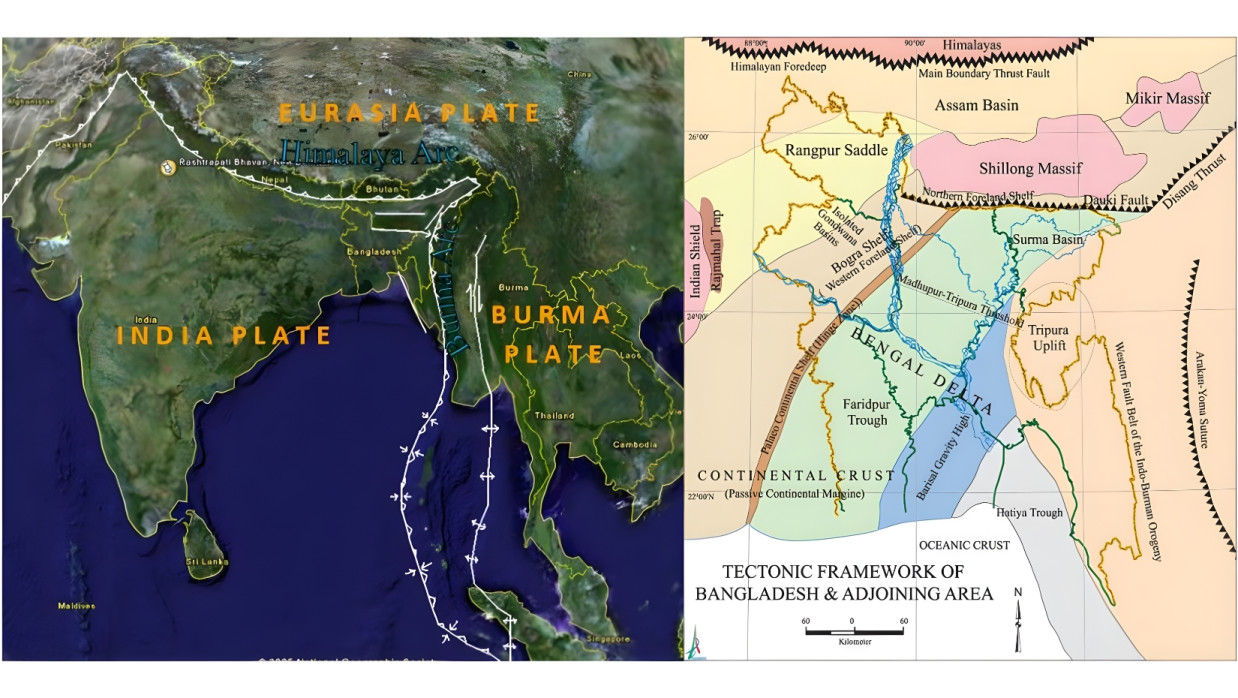
The second followed at 6:06:05 pm, registering a magnitude of 4.3, and was centered in Narsingdi. It has sparked discussions on Bangladesh's three geological plates and six faults, which are primarily responsible for earthquakes in the capital and other regions.
Bangladesh's geological plates and faults
Officials from the Meteorological Department and other agencies say Bangladesh lies at the junction of several geological plates and faults. Here's a detailed look:
Key tectonic plates Bangladesh is mainly situated at the convergence of three major plates:
- Indian Plate: Covers a large part of Bangladesh's east and north, colliding with the Eurasian Plate to the north and the Burma Plate to the east.
- Eurasian Plate: Lies over the Himalayan region, north of Bangladesh. Its collision with the Indian Plate triggers quakes in the Himalayas and northern areas.
- Burma Plate (Burma Microplate): Located in Myanmar to the east of Bangladesh. It hosts the highly dangerous Indo-Burma megathrust.

Bangladesh's major active faults The most significant faults within and along the borders are:
- Dauki Fault: Located at the foothills of Meghalaya in Sylhet. A major thrust fault with potential for 7–8 magnitude quakes. Affects Sylhet, Mymensingh, Netrokona and Moulvibazar districts.
- Madhupur Fault: Runs west of Tangail-Mymensingh-Gazipur. Risk of 6.5–7 magnitude quakes, strongly felt in Dhaka. Impacts Tangail, Mymensingh, Sherpur, Gazipur, Kishoreganj and Dhaka.
- Chattogram Fold Belt Faults: In the hilly Chattogram region. Multiple active faults from crustal compression. Affects Chattogram, Bandarban, Rangamati, Khagrachhari and Cox's Bazar.
- Indo-Burma Megathrust (Subduction Zone): East of the Bangladesh-Myanmar border. One of Asia's most dangerous subduction faults, with potential for >8.5 magnitude. Impacts Cox's Bazar, Bandarban, Chattogram, Feni, Noakhali, Laxmipur and Brahmanbaria.
- Shillong Plateau Boundary Faults: In India's Shillong-Meghalaya highlands. Risk of recurrence like the 1897 quake. Affects Sylhet, Netrokona, Sunamganj and Mymensingh.
- Teesta Lineament, Playa-Ganga Lineament: In the northwest, with relatively lower risk. Impacts Rangpur, Dinajpur and Thakurgaon.
Districts at risk Based on overall seismic hazard levels:
- Highest risk (extreme): Dhaka, Sylhet, Chattogram, Cox's Bazar, Tangail, Mymensingh, Gazipur.
- High risk: Moulvibazar, Netrokona, Sherpur, Sunamganj, Rangamati, Bandarban, Khagrachhari, Brahmanbaria, Noakhali, Feni.
- Moderate risk: Rajshahi, Rangpur, Dinajpur, Kushtia, Jessore, Khulna, Barishal.